Salt marshes, thick with pluff mud and dominated by spartina grasses, are in a constant state of change. If you have experienced tidal cycles in the Port Royal Sound firsthand, you have seen new creeks form, sandbars shift, and marshes come and go. What is driving this change, and how do marshes behave in this dynamic system? The short answer is — we don’t really know! But through the PRSound Science initiative, we are establishing some projects help us monitor changes in our marshes to start figuring it out.
Salt marshes are intertidal coastal wetlands defined by their symbiotic relationship with tides. Twice-daily tidal cycles inundate the marsh with saltwater — distributing nutrients, removing waste, depositing sediment to raise elevation, and defining distinct high and low zones. But marshes ultimately need to be exposed for parts of the day to allow oxygen to reach the sediments and roots to stay alive. These are dynamic systems that need to adapt to their conditions to remain vibrant and productive. They adapt through a process called migration.
Marsh migration can happen in two ways: moving horizontally inland to higher ground, or vertically through sediment accumulation – a process called accretion. Horizontal migration depends on unobstructed space for marshes to move. Conserving open spaces and maintaining natural (not armored) shorelines provides room for marshes to move inland as they need to. We can observe this transition in marshes historically dominated by black needle rush evolving into spartina-dominated marshes. The processes behind vertical migration – marsh accretion and subsidence – are less well understood.

Marshes are one of our greatest protections against storm surges and coastal flooding. They do so by absorbing water when inundated, then slowly releasing it as water levels recede and marshes are exposed. With each of those inundation cycles, sediments suspended in the water settle on the surface of the marsh, adding to the elevation of the marsh. The rate of accretion has historically been sufficient to maintain the vitality of our marshes. But with rising sea levels, that balance has been disrupted. The questions now are whether the rate of accretion in our marshes can maintain or outpace rising sea levels to keep them from drowning? If not, do marshes have room and clear corridors to migrate inland? And if neither case is true, what can we do to conserve our marshes before they disappear?
Significant work is underway in South Carolina to understand and model marsh migration corridors and how quickly migration might occur. For example, check out this new tool developed to model marsh change in the ACE Basin just north of the PRS!

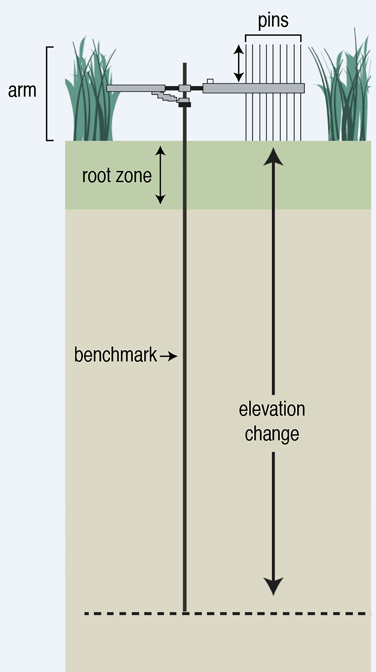
But what has been missing in the Port Royal Sound watershed is data about changes in marsh elevation. Scientists monitor and quantify changes in marsh elevation using measurements from Rod Surface Elevation Tables (RSET) stations.
RSET Stations are essentially stainless steel rods driven through the marsh sediments to the ‘point of refusal’ to become a stationary point in the marsh. A researcher attaches a device resembling a crane arm to the stationary rod and takes a series of measurements to record the relative change in elevation in that section of the marsh. These measurements are taken quarterly to account for seasonal variation. Over years and decades, repeated measurements reveal relative changes in the elevation of the marsh – it’s either increasing in elevation relative to that stationary point (accreting) or losing elevation (subsiding). Then, you can analyze those changes relative to sea level rise and get a better idea of the future for that marsh.
The SCDNR Geological Survey monitors RSET stations along the South Carolina coast, but there had not been any stations installed to support monitoring in the Port Royal Sound watershed. So, when the Southeast Coastal Ocean Observing Regional Association (SECOORA) received federal funds to expand the network of RSET stations along the southeast coast, the Port Royal Sound Foundation applied and was awarded funding to install 12 stations in the PRS watershed.
Starting in July 2025, Port Royal Sound Foundation and the University of South Carolina – Beaufort, with support from the SCDNR Geologic Survey team, embarked on an eight-month journey to install 12 RSET stations in marsh sites adjacent to public, private, county, and military lands. With countless truckloads of lumber, stainless steel rods, sledgehammers, jackhammers, and snacks and sunscreen, we built the Port Royal Sound RSET Network – a first step towards building a comprehensive long-term marsh monitoring project.

Each RSET station consists of two low 8’ wooden piers installed parallel to each other, about 6 feet apart, to protect the small plot researchers will be monitoring for hopefully the next fifty years! Rule #1 – don’t step in the study site!
Once the piers were constructed, we extended aluminum scaffolding over the study plot, allowing us to stand over the plot and hammer 4’ sections of ⅜” stainless steel rod down through the marsh sediments. Hammering started with a tomato stake driver, then moved to a 60-pound jackhammer as it got harder to drive the rod. As the rod descended into the earth, new 4’ sections were threaded onto the continuous rod that was going deeper and deeper into the marsh. When the rod stopped driving down into the ground, and we had reached the ‘point of refusal’, we attached the receiver for the measuring device, cemented it in place, slapped the finished work a few times, and exclaimed, “Well, that’s not going anywhere!”
The rod depths, descending to the point of refusal, varied dramatically throughout the watershed. The shallowest site was about 32’ on the Pocotaligo River; the deepest site was close to 80’ on the Broad River side of Parris Island.
Port Royal Sound Foundation and USCB now have a permanent network of study sites to take fine-scale measurements (to the millimeter scale) of changing marsh elevation, hopefully for the next 50+ years. With the installation work behind us, we will begin taking measurements at these stations in May 2026. It will be two years before we can begin to detect minute changes, and likely at least 10 years before we can make definitive claims. The Port Royal Sound Foundation is committed to conserving a clean and healthy Port Royal Sound, and this is one of the many ways we are advancing that mission.
A special thanks to all of our partners who helped us get these SET stations in the ground — SECOORA, SCDNR Geological Survey, USCB, SCDES, Spring Island Trust, Bray’s Island, Beaufort County, and MCRD Parris Island.
Interested in learning more about marsh migration, RSET stations, and other work happening to conserve and protect our salt marshes? Join us for March Madness on Saturday, March 21. From 12-3pm, we will be hosting a Salt Marsh Conservation Expo in the Maritime Center, where several of our partners will be on hand to share their work in our salt marshes and answer your questions. Then, from 3-6pm, we will be hosting our annual oyster roast, which directly supports this work! Tickets are $60pp, and the event is 21+. Learn more and buy tickets today!